Microsoft Streets and Trips has always been a favorite when it comes to planning trips. That doesn’t really change with Microsoft Streets and Trips 2010, although some of the updates are not all that exciting.
For those unfamiliar with Streets and Trips: in effect, it makes your netbook or laptop into a complete device for trip planning and GPS navigation. As was the case with earlier versions, Streets and Trips 2010 comes in two different forms: the software-only version, with a price tag of $40, and the software / GPS locator combo package for $70. Streets and Trips works with most NMEA 2.0-compatible GPS receivers, so if you already have a suitable receiver, you just need the software.

The newest version is not that much of an advance on the previous one. It does include updated U.S. and Canadian maps, as well as some timely additions to the lists of points of interest. The major innovation, though, is the ‘Send to GPS’ feature, and also a useful function for exporting route info in GPX format. These additions are reasonably welcome, even though they are of somewhat limited use.
There are two methods for exporting to GPS. You can do updates via MSN Direct, but this must be supported by the device and an active subscription is also required. According to Microsoft’s list of supported devices, there are only a few models from Pioneer, Nextar and Garmin capable of using this feature. Some GPS devices can be upgraded via USB, using an Internet connection on a computer. An MSN Direct subscription is not necessary for this, but it does require the installation of an ActiveX control which needs to be downloaded, and can only be used by Garmin devices. The feature for exporting GPX works as described, but is not supported by all GPS devices.
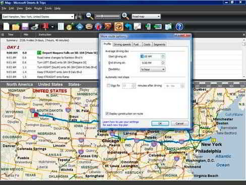
Where Streets and Trips really comes into its own though, is in planning trips. Just enter the names or addresses of one or more locations, and Streets and Trips takes it from there. If you know three or more waypoints, you can have Streets and Trips optimize the entire route, or you can organize a number of trip segments in the order you prefer. Based on customizable route preferences, Streets and Trips will calculate your entire route for you, including both a map overview and turn-by-turn directions. If at the beginning of your trip you enter your gas tank’s size, your average mileage and the status of your gas tank, Streets and Trips will prompt you when you are likely to need to refuel. And if you also input the current price of gas, Streets and Trips will display a fuel cost estimate below your directions list.
Once your route is planned and generated, you are presented with a number of options as to how you would like it displayed. You can view just the map on its own, include the list of directions, or add a direction pane to that as well. Assuming your GPS device is active and receiving sufficient satellites, you can have the navigation pane display the distance before your next turn, as well as its direction. You also have the option for the GPS pane to display the speed you’re travelling at, as well as the time, altitude, latitude, longitude and direction in which you’re travelling. Additionally, the full screen mode lets you recover display space used by the menu.
Although the newest features are not in themselves all that impressive, for $40 it’s worth upgrading to Microsoft Streets and Trips 2010 even if it’s just to obtain the latest maps. If you’re still using a version from 2008 or earlier, this version is practically a must-have for the fantastic text-to-speech feature – a feature definitely worth having in any navigation device or program.